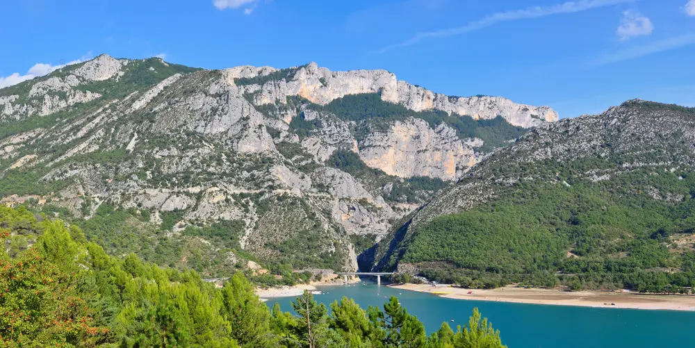
The Verdon’s great turquoise lake
Lake Sainte-Croix
About 22 km² of emerald water between the grand canyon and Provence, bordered by five villages across two départements. Here’s how to find your way around: which beach, which village, which activity — and what you need to know before you swim.
- What it is
- A turquoise reservoir lake, flooded by EDF in 1973
- Surface area
- ≈ 22 km², about 80 m deep at its deepest
- Lakeside communes
- Sainte-Croix-du-Verdon, Aiguines, Bauduen, Les Salles-sur-Verdon, Moustiers-Sainte-Marie (Galetas)
- Territory
- 2 départements — Alpes-de-Haute-Provence (04) and Var (83)
- Supervised swimming
- Only a few beaches, in July-August, including Sainte-Croix-du-Verdon (village), Margaridon (Les Salles) and the Galetas (Aiguines)
Getting your bearings around the lake
The beaches, one by one
Galetas, Margaridon, Bauduen, Chabassole… which beach, on which shore, supervised or not, dogs allowed.
All the beaches →The Pont du Galetas
The bridge at the entrance to the lake: where the Verdon leaves the grand canyon and opens onto turquoise water.
The Pont du Galetas →Canoeing & electric boats
Paddle or drive licence-free up the first cliffs of the canyon, from the Galetas.
Canoeing at the Galetas →Swimming & safety
Cold water at depth, rarely supervised, EDF water releases: what you need to know before you jump in.
Safety in the Verdon →Sunset over the lake
The verified viewpoints for watching the sun go down over the turquoise water — and what we actually know about the Col d’Illoire.
See the spots →The five villages of the lake
The village beach, supervised in summer — the easiest spot to land for a swim.
Aiguines Left bank, gorge entrance (83)At the foot of the Corniche Sublime, with a view over the lake from the perched village.
Bauduen South shore (83)A medieval village, with its esplanade by the water.
Les Salles-sur-Verdon East shore (83)Shaded family beach, municipal water sports centre — rebuilt after the lake was flooded in 1973.
Moustiers-Sainte-Marie North shore, Galetas side (04)The faience and a much-visited village, a few minutes from the lake.
The drowned village
In 1973, EDF filled the reservoir of the Sainte-Croix dam, a double-curvature arch dam about 95 metres high, to produce electricity and supply Provence with drinking water. The reservoir created a lake of about 2,200 hectares and 760 hm³. Filling began in August 1973; it became final on 15 November 1973, but the water kept rising for another year and a half, until April 1975, to reach its full level.
This rising water gave the old village of Les Salles-sur-Verdon no respite: by February 1974, what remained of it was no more than a heap of ruins surrounded by water. At dawn on 1 March 1974, the gendarmerie evacuated the last inhabitants. Five days later, on 5 March, the church bell tower was dynamited. Of the 165 inhabitants recorded in 1968, only 125 would settle in the new village, rebuilt higher up: the compensation, judged too low by the villagers, prevented several families from rebuilding. It is the only village submerged when Lake Sainte-Croix was filled.
The lake swallowed a second place, less well known but just as striking: the spring hamlet of Fontaine-l’Évêque, a few kilometres from Les Salles. Its resurgence — fed by an underground network that drains the Canjuers plateau for nearly 40 km — was studied as early as 1905 by Édouard-Alfred Martel, the same explorer who crossed the Verdon’s grand canyon that year, then by the speleologist Robert de Joly in 1928 and by Commandant Cousteau in 1953, who judged the siphon impassable; Franco-Belgian divers pushed the limit to -44 m in 1966. Paradoxically, it is this spring that saved Bauduen and Sainte-Croix-du-Verdon from drowning: fearing a siphon effect towards the underground water table if the lake rose too high, the engineers lowered the dam’s water level from 500 to 482 metres — a choice that submerged Fontaine-l’Évêque under some sixty metres of water, but spared the two villages, which stand higher up on the shores.
Water temperature, season by season
There is no official month-by-month record for Lake Sainte-Croix: here is what can be established by cross-checking several independent temperature trackers against the well-documented behaviour of a deep reservoir lake (about 80 m at most), where the surface warms quickly but the bottom stays cold all year round.
5 to 8 °C — nobody swims; the shores can freeze overnight in some years.
10 to 15 °C — the water warms up slowly, still cool at the end of May barring an exceptional heatwave.
20 to 25 °C — the real swimming season: about 20 °C from June, a peak of 24-25 °C in late July-August (up to 26-29 °C at the surface during heatwaves), still around 20 °C in September.
5 to 15 °C — rapid drop: 10-15 °C in October, below 10 °C by mid-November.
Indicative figures, cross-checked between several surface temperature trackers (not EDF, unofficial): actual values vary with the year, the weather and the water releases. The only certainty, checked against sources: the bottom water of a dam reservoir does not follow the surface, hence the cold-water shock warnings on our beaches and safety pages.
Frequently asked questions
Is Lake Sainte-Croix natural?
No, it’s an artificial reservoir lake: EDF flooded the former Verdon valley in 1973 by building the Sainte-Croix dam, downstream. The village of Les Salles-sur-Verdon, submerged by the flooding, was entirely rebuilt a little further up. It is this dam that gives the lake its characteristic turquoise colour and its great depth (about 80 m at most: 75 m measured and 83 m theoretical, according to the Agence de l’Eau Rhône-Méditerranée-Corse, the regional water agency). You will sometimes see 90 m, or even 93 m, on tourism or encyclopedia sites, but those figures do not appear in the water agency’s official data sheet, which is our reference here.
What is the water temperature in Lake Sainte-Croix?
It varies enormously with the season: below 10 °C from December to March, a rapid warm-up in spring, comfortable water from June (around 20 °C), a peak around 24-25 °C in late July-August (up to 26-29 °C at the surface during intense heat), then a rapid drop from September-October. These are surface averages: at depth, the water of a dam reservoir stays cold all year round, hence the risk of cold-water shock when diving in suddenly.
Is Lake Sainte-Croix the largest lake in France?
No. It is a reservoir lake of around 2,200 hectares; the large coastal lagoons (Berre, Thau…) are much bigger.
Which communes border Lake Sainte-Croix?
Five, across two départements: Sainte-Croix-du-Verdon and Moustiers-Sainte-Marie (north shore, Alpes-de-Haute-Provence), Aiguines, Bauduen and Les Salles-sur-Verdon (south and east shore, Var). Each has its own beach and its own character.
Where to stay by Lake Sainte-Croix?
It depends on the atmosphere you’re after: Sainte-Croix-du-Verdon for simplicity (village beach, supervised swimming); Bauduen for the authenticity of a real medieval village; Les Salles-sur-Verdon for a family base; Aiguines to combine the lake with the Corniche Sublime. Our “where to stay” guide details each area of the Verdon.
Can you drive around Lake Sainte-Croix?
Yes, the road that runs along the lake (D957 on the Galetas side, then D19 and D71 depending on the direction) links the five lakeside communes in half a day with stops. The mandatory crossing point is the Pont du Galetas, between the lake and the entrance to the grand canyon.