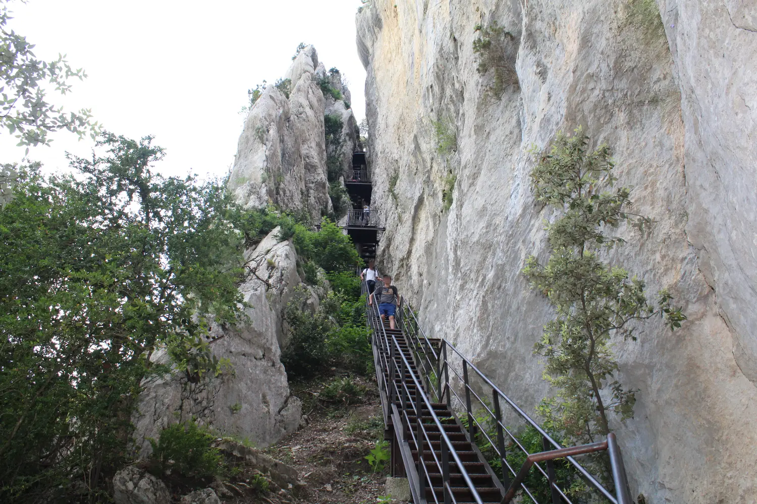
The Blanc-Martel trail is the best-known hike in the Grand Canyon of the Verdon, according to Verdon Tourisme — and yet no source agrees on its numbers: distance ranges from 13 to 16 km, elevation gain from 500 to 1,160 m, duration from 4 h 30 min to 8 h depending on the source. This guide settles the question, backed by official sources, and gives you everything you need to hike it safely.
Figures verified on 5 July 2026 and re-read on 4 October 2026 with the Parc naturel régional du Verdon (the trail’s official manager), Verdon Tourisme, and the Castellane-Verdon Tourist Office; detour revalidated on 14 October 2026.
Ongoing detour: Couloir Samson → Point Sublime
A rockfall has damaged the trail on its final stretch. A municipal order from Rougon temporarily closes access between the Couloir Samson exit and the Point Sublime. The full hike remains possible: from the Couloir Samson exit, take the RD23A departmental road, then the GR49 trail to the Point Sublime — the manager’s stated total duration does not change. Do not enter the zone marked by the signage, and do not attempt to cross the rockfall area. Check with the Parc naturel régional du Verdon before you go.
The essentials
| |
|---|
| Distance | 15 km |
| Elevation gain | 600 m |
| Duration | 5 h 30 min without breaks (with the shuttle: 7 h 30 min between the 8:30 outward trip and the 16:00 return) |
| Difficulty | Moderate to difficult — exposed sections |
| Type | Linear traverse (return shuttle required) |
| Start | Chalet de la Maline (900 m), La Palud-sur-Verdon |
| Finish | Point Sublime, Rougon |
| Waymarking | Section of the GR4 |
The route, step by step
The classic direction runs from the Chalet de la Maline (right bank, along a balcony path) toward the Point Sublime, gradually descending into the floor of Europe’s Grand Canyon.
- Start at Chalet de la Maline (900 m) — the trail plunges into the gorges along a balcony ledge.
- The Imbert breach — the spectacular section: 6 ladders and 252 metal steps, roughly 100 m of descent in one go.
- La Mescla — the confluence of the Artuby and the Verdon (a classic, superb detour).
- The Estellier footbridge — swept away by the once-in-a-century flood of November 1994, since rebuilt.
- The Couloir Samson tunnels — 3 tunnels in use (the Baou, 670 m; Trescaire, 110 m; les Baumes). Headlamp required.
- Arrival at Point Sublime (Rougon) — exiting near the Couloir Samson car park, where the shuttle awaits.
The shuttle: required, and here’s how it works
Since the Blanc-Martel is linear, you need to plan your return. The official solution is the Park’s shuttle, by reservation.
- Booking: navette.parcduverdon.fr (bookings close every day at 18:00 for the next day).
- 2026 periods: Friday, Saturday, Sunday, public holidays and long weekends from 3 April to 28 June; every day from 29 June to 14 September; Thursday, Friday, Saturday, Sunday and Monday from 17 September to 1 November.
- Schedule: a typical return trip leaves La Palud-sur-Verdon at 8:30 and comes back at 16:00 from Point Sublime — that is 7 h 30 min between the two times, including the shuttle ride to the start of the trail, for a 5 h 30 min walk (confirmed live on the booking calendar, several September 2026 dates). In peak season the Park can add up to 3 shuttles a day depending on demand: the exact slots for a given date only show up in the booking calendar, there is no fixed published timetable for that period.
- Price: €8.50 round trip for adults, €5.50 for children (under 12), €4.50 one-way (2026 rates, reconfirmed live).
- Good to know: the Point Sublime stop is a 20-minute walk from the trail’s end; the shuttle does not go back to the Chalet de la Maline in the afternoon — to get your car back the same day, park in La Palud-sur-Verdon (dedicated car park).
- Without the shuttle: two cars, a taxi or a short walk; see the next section.
If the shuttle is full or not running
The shuttle does not run every day. In 2026, it runs every day only from 29 June to 14 September. From 3 April to 28 June, it runs on Fridays, Saturdays, Sundays, public holidays and long weekends; from 17 September to 1 November, from Thursday to Monday, so not on Tuesdays or Wednesdays.
The 2026 season ends on 1 November; the opening day for the next season’s bookings is announced on the booking website from the second half of March. Note: that website’s FAQ, updated on 17 February 2026, still describes a Friday-to-Sunday service after mid-September; the same website’s home page and the Verdon Park’s website give a Thursday-to-Monday service, from 17 September to 1 November. Check your date in the booking calendar.
If the shuttle is full:
- Without a booking, a seat is not guaranteed. A ticket can be bought on board on the day, in cash or by card, only if seats are left.
- Aim for the last morning shuttle, usually the least in demand, according to the official website. The seats still on sale on board can be checked on the booking website until the morning of departure.
- In peak season, an extra shuttle can be added up to 48 h before departure, when bookings reach a threshold (3 shuttles a day at most): check the calendar again.
To get back without the shuttle:
- With two cars: leave one at the Chalet de la Maline (very few spaces) and the other at the finish, in the Couloir Samson car park (paid only in summer, from the start of the school holidays to 31 August, price per entry).
- By taxi, booked the day before: Taxi Castellane (SAS SERANTO), which lists the Blanc-Martel trail among its services, or Taxi Verdon, in La Palud-sur-Verdon, which offers the trip from Point Sublime or the Samson car park to the Chalet de la Maline. Their numbers are on our Verdon taxis page; ask for the price before confirming.
- On foot: allow 8 km from Point Sublime to La Palud-sur-Verdon, then 8 km to the Chalet de la Maline, on top of the hike. To walk without a shuttle or a second car, there is the Petit Sentier Blanc-Martel, rated difficult: about 5 km there and back (2 h 45 min) from the Chalet de la Maline.
Sources: navette.parcduverdon.fr (home page, “Le service navette” page, FAQ), parcduverdon.fr, Taxi Verdon’s listing on verdontourisme.com and our Verdon taxis page (checked on 2026-10-09); consulted on 2026-10-14.
Safety & equipment
- A headlamp is required for the tunnels (the Baou alone runs 670 m).
- At least 3 L of water per person (the minimum given by the Verdon Park): no supply points anywhere along the route.
- Dogs and mountain bikes banned.
- Swimming strictly forbidden in the Verdon, to protect the apron du Rhône (an endemic fish threatened with extinction).
- Vertigo: several exposed sections — not recommended for children under 8.
- EDF water releases: the level of the Verdon can rise quickly. Never go down into the riverbed without checking the day’s releases (from the Castillon and Chaudanne dams).
- Heat: in July-August it goes above 30°C in the gorges — set off before 7am.
A bit of history
The first full traverse of the gorges took place from 11 to 14 August 1905, led by the explorer Édouard-Alfred Martel, commissioned by the Ministry of Agriculture, accompanied notably by Isidore Blanc, the schoolteacher-guide from Rougon. The trail was built in 1928 by the Touring Club de France, named the “sentier Martel” in 1930, then renamed “sentier Blanc-Martel” in 2005 to also honor Isidore Blanc. A major renovation took place in 2012-2013.
Sources
Data cross-checked and verified on 2026-07-05: PNR du Verdon (navette.parcduverdon.fr), Verdon Tourisme, OT Castellane-Verdon, Wikipedia (Sentier Martel; É.-A. Martel), AllTrails, Visorando, Outdooractive, Wikiloc, camptocamp, FFRandonnée, GEO, Routard. Discrepancies retained and settled above. Couloir Samson → Point Sublime detour verified 2026-08-22, reconfirmed 2026-09-06, 2026-09-20 and again 2026-10-17 (Rougon municipal order no. 750 of 2026-08-14 still online, no reopening date announced): navette.parcduverdon.fr (dedicated page “Le sentier Blanc-Martel”). Shuttle calendar and schedule re-checked live on 2026-09-20 (real browsing of the official booking site — homepage, FAQ, booking calendar on several September dates): periods corrected, typical 8:30/16:00 schedule published for the first time. No data invented: a missing field means it still needs verification.